-

-
-
-
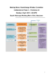
Ruamāhanga Whaitua Committee meeting/Monday 3 April 2017
WHEN: Monday 3 April 2017, 1:30-6PM
WHERE: South Wairarapa Working Men’s Club, Greytown
alarm Published 03 Apr 2017 -
Hydrology State of the Environment monitoring programme Annual data report, 2015/16
This report contains key results from the Hydrology State of Environment (SoE) monitoring programme for the period 1 July 2015 to 30 June 2016 inclusive.
Keywords: Hydrology annual report rainfall river…alarm Published 01 Apr 2017 -
Terrestrial Ecology State of the Environment monitoring programme: Annual data report, 2015/16
This annual report details the results of the Terrestrial Biodiversity State of the Environment monitoring programme for the period 1 July 2014 to 30 June 2016. Vegetation, birds and pests…
alarm Published 01 Apr 2017 -
Hutt Estuary: Intertidal Macroalgal Monitoring 2016/17
This report presents the findings of macroalgal cover monitoring as a broad scale indicator of nutrient inputs undertaken in the Hutt Estuary in January 2017.
Keywords: Hutt River, Hutt Estuary,…alarm Published 01 Apr 2017 -
Hutt Estuary: Intertidal Sediment Monitoring Summary 2016/17
This summary card presents the findings of sedimentation rate monitoring at a single site in the Hutt Estuary undertaken in January 2017. The sedimentation rate over the past seven years…
alarm Published 01 Apr 2017 -
Porirua Harbour: Intertidal Macroalgal Monitoring 2016/17
This report presents the findings of macroalgal monitoring as a broad scale indicator of nutrient inputs undertaken in Porirua Harbour in January 2017. The results show widespread macroalgal presence, though…
alarm Published 01 Apr 2017 -
Porirua Harbour: Sediment Plate Monitoring 2016/17
This report presents the findings of sediment monitoring at nine intertidal and nine subtidal sites within Porirua Harbour. This monitoring was undertaken in January 2017 and included assessments of…
alarm Published 01 Apr 2017