
A brief summary of climate and hydrological conditions in the region.
This service is regularly updated during periods in which closer monitoring is required (regardless of time of the year), in recognition that there is potential for dry spells, or irregular hydrological recharging. It does not define an official council position on drought or drought declaration. Outside of dry periods, less frequent updates synchronise with our latest seasonal outlooks.
Updated 25 September 2026
Next update due when there is a significant change of conditions or a new seasonal outlook.
El Niño continues to rapidly intensity, but no clear signs of Wairarapa dryness as of the spring equinox
View Earth Sciences NZ's El Niño tracker
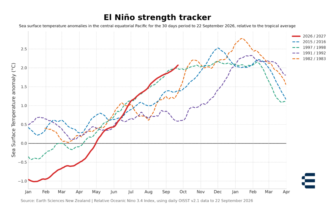
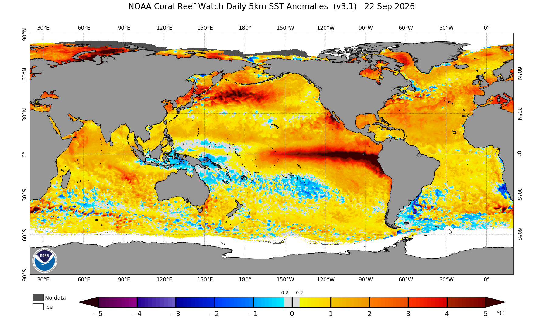
The daily El Niño tracker by ESNZ (upper panel) shows that the current event (red line on the graph) has intensified at a rate greater than all known historical events – as indicated by the steepness of the line – and is currently tracking very closely to the 1997/1998 El Niño. This doesn’t mean that the impacts will be the same, as each El Niño is different and the climate is changing. The latest global SST anomalies are shown immediately above, where we can see that despite the ENSO signature in the Pacific Ocean, the water temperatures are still above average around New Zealand. This feature might work against a more severe dryness. For dry historical El Niño years in the Wairarapa, the water temperatures around New Zealand have been traditionally well below average. Credits: ESNZ and NOAA.
Background
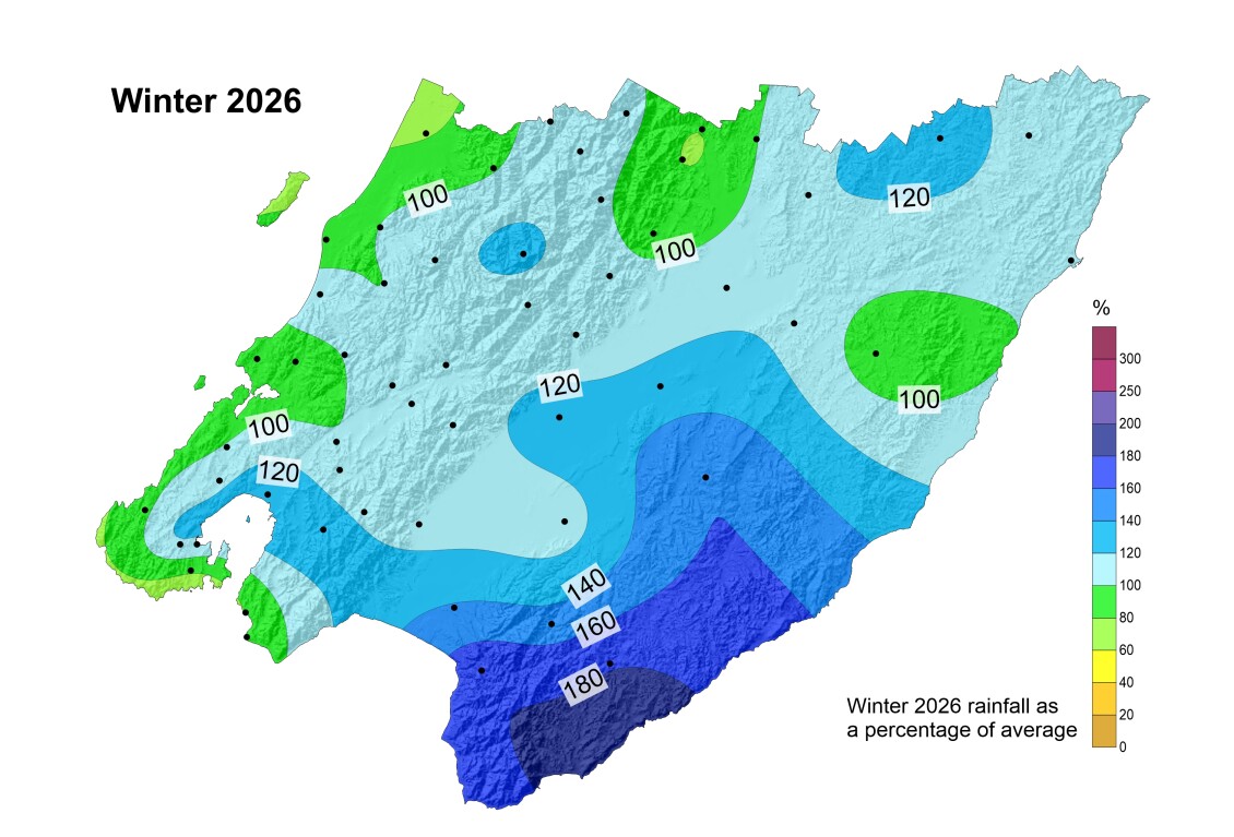
Winter and early spring were characterised by a very variable climate regime with remarkable temperature fluctuations across the region, as well as extreme rainfall episodes and isolated downpours during severe thunderstorms. Parts of the Wairarapa are still recovering from flood damage. While much of August was relatively settled and dry, there has been no clear anomalous drying trend in the rainfall pattern (other than the normal post-winter drying) by the spring equinox, regardless of the strengthening El Niño in the background.
Current situation
Soil moisture levels were sitting at the normal or above average mark for most of the Wairarapa by the spring-equinox. A strong westerly flow typical of El Niño springs is getting progressively established over the region, even though we are still seeing breaks in the circulation with good easterly rainfall replenishment in the Wairarapa. River flows and groundwater levels are generally holding up after several rainfall fronts and modest freshes in early September and tracking well within the historical normal range for this time of year.
Meteorological outlook
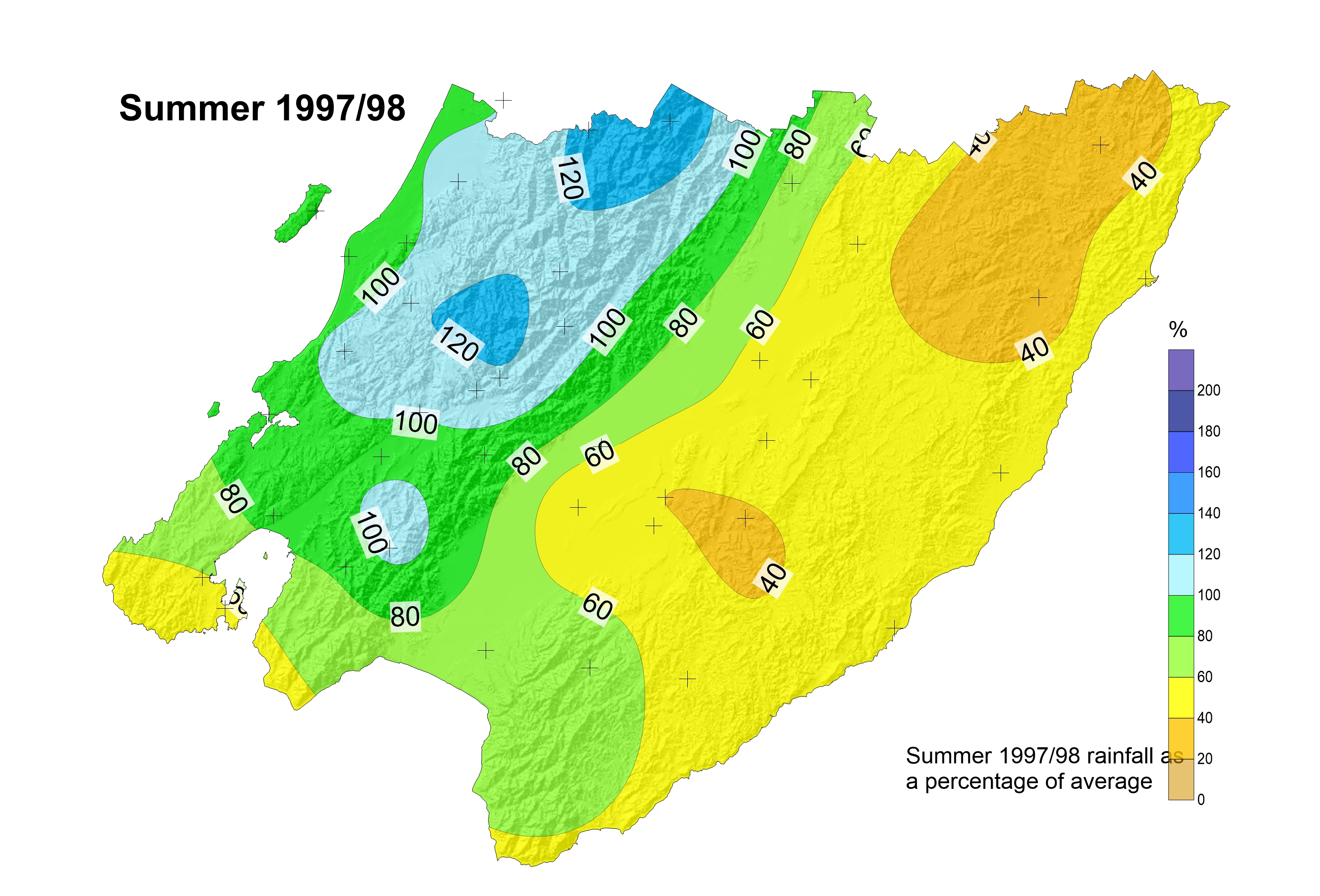
The El Niño is currently tracking very closely to the historical 1997/1998 event. However, each El Niño is different and impacts in our region can be variable and ‘hit and miss’, compared to other parts of New Zealand and the world. There is still uncertainty in model projections, compared to the observations, as to whether this year’s event will stabilise at similar levels compared to historical El Niños (refer to real time tracker above), or whether the 2026-2027 El Niño will surpass all past events by a significant margin, as some models suggest. Latest projections for the synoptic flow anomalies depict a persistent, vigorous westerly flow strengthening into spring and towards the end of the year, with an anticyclone prevailing over the Tasman Sea. While this configuration should lead to some degree of dryness east of the ranges, whether this set up will turn into a more significant summer drought remains unclear. Paradoxically, with climate change, a warmer ocean in our region might work to partially counteract the more severe, traditional dryness impacts through increased moisture from evaporation. During traditional El Niños such as in 1997, water temperatures around New Zealand have been much cooler than average. This is unlikely to be repeated this year even though some local SST cooling is projected towards the end of the year.
|
|
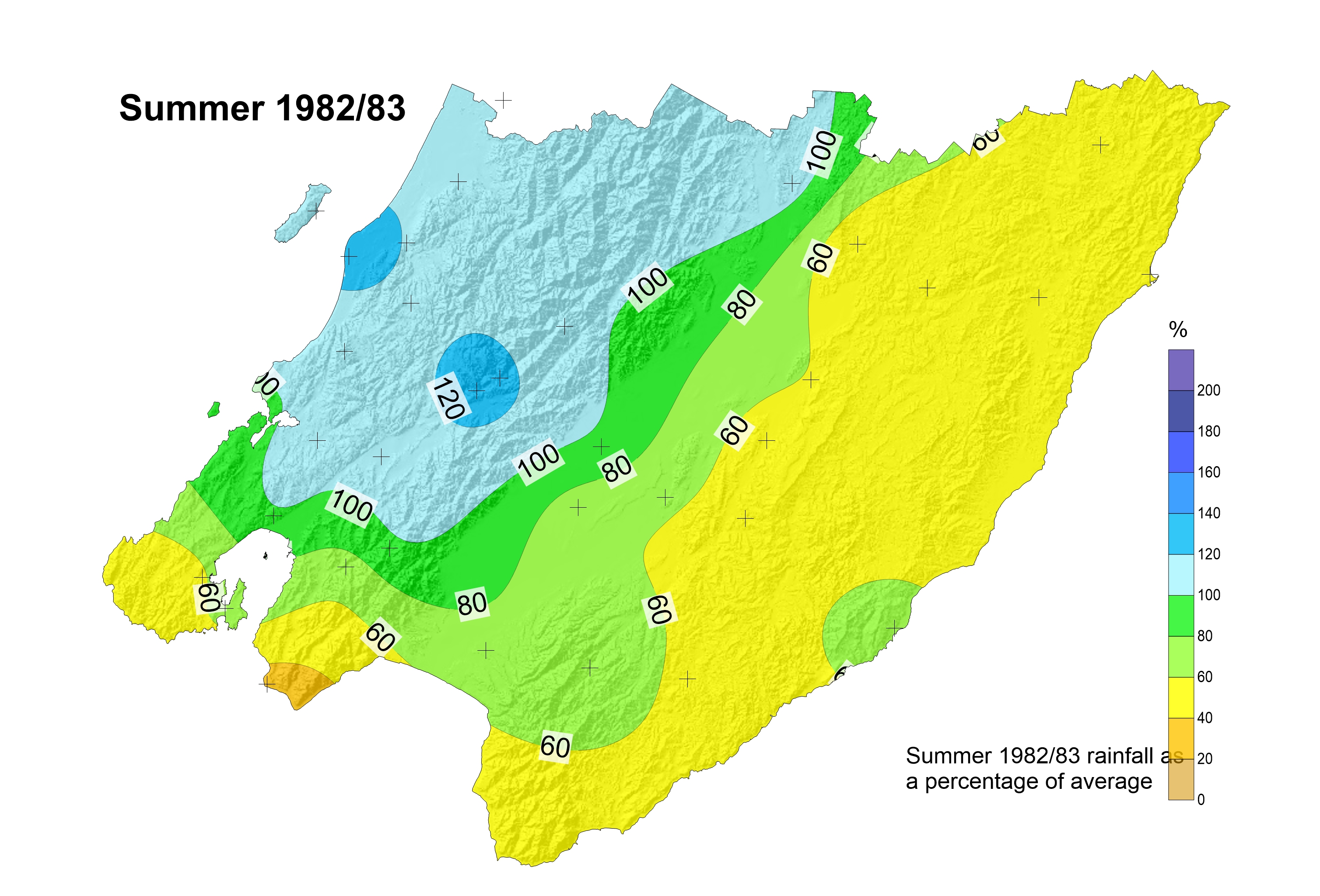
| Rainfall anomalies during summer for the historical previous strongest El Niños on record of 1982/83 and 1997/98. We can see that both cases had rainfall above average over the Tararua ranges and around Kāpiti, with below average rainfall in the Wairarapa, south of Wellington city and Baring Head. Credits: Greater Wellington | |
The table below summarises potential El Niño impacts for the Wellington region as a whole during the coming spring and summer months. In light of the potential for extended dryness over the summer months in the Wairarapa, we strongly recommend a continuous monitoring of how the hydrological conditions will evolve during spring, along with the seasonal outlooks and daily data available on our seasonal climate portal and also by Earth Sciences New Zealand.
| Projected El Niño climate impacts for spring and summer – global and region wide summary | Spring 2026 | Summer 2026-2027 |
|---|---|---|
| High confidence global projections | There is high confidence that this El Niño will be one of the strongest in recorded history, with severe global impacts. However, the Wellington Region is located in a transition area, and El Niño impacts are normally only mild for us compared to Hawkes Bay, Canterbury and other areas of the world such as South America, California, Australia and South-east Asia | The event, albeit very strong, might be short lived and start decreasing in intensity towards the second half of summer. Even though, its effects could still be felt for longer. |
| Overall projected regional Impacts | Increased westerly winds and gusts, moderate to severe drying in the Wairarapa (especially eastern coast) and Baring Head area. Likely low flows east of the main ranges, and increased fire risk in several areas including Baring Head and Wairarapa, especially as a result of increased winds | As per spring, with drying effects reaching their peak and likely starting to decrease into autumn |
| Areas of uncertainty | Every El Niño is unique and not every event will have a clear dry pattern in spring. Climate change has warmed the oceans around New Zealand, and warmer waters might work to partially counteract the traditional effects of a more severe drying in our region | Every El Niño is unique and not every event will have a clear dry pattern in summer. Climate change has warmed the oceans around New Zealand, and warmer waters might work to partially counteract the traditional effects of a more severe drying in our region |
Climate change
The ‘normal’ longer-term water balance is becoming increasingly hard to maintain quite possibly due to climate change influences, and increased high frequency climate variability, with more unreliable weather patterns. Droughts are expected to become more severe and frequent in the Wellington region, particularly in the Wairarapa. Even if international climate policy efforts were to successfully contain global warming under 1.5-2 degrees (the Paris Agreement’s ambition), it is important that we enhance our water resilience and be prepared for more unreliable climate patterns with both extreme dry and extreme wet periods. We note that the warming of the land also means that evapotranspiration will greatly increase, so the soil will likely need more ongoing rain to maintain ideal moisture levels, compared to what it has needed in the past.
View the latest national drought index state
View the national drought forecasting dashboard
View the latest seasonal report:
Climate drivers and seasonal outlook for the Wellington Region - Winter 2026 summary Spring 2026 outlook
date_range Published 24 Sep 2026
Download now (PDF 1.9 MB) get_appBrowse the data
Anomaly Maps
How different has recent rainfall/soil moisture been compared with the same time in previous years?
Site-specific graphs
| Area | Rainfall | Soil Moisture |
| Kapiti Coast (lowland) | Otaki at Depot | |
| Kapiti Coast (high altitude) | Penn Creek at McIntosh | |
| Porirua | Horokiri Stream at Battle Hill | |
| Wellington City | Kaiwharawhara Stream at Karori Reservoir | |
| Hutt Valley (upper catchment) | Hutt River at Kaitoke Headworks | |
| Upper Hutt | Upper Hutt at Savage Park | Upper Hutt at Savage Park AQ |
| Wainuiomata | Wanuiomata River at Wainui Reservoir | |
| Wairarapa (high altitude) | Waingawa River at Angle Knob | |
| Wairarapa Valley (north) | Kopuaranga River at Mauriceville | |
| Wairarapa Valley (Masterton) | Ruamahanga River at Wairarapa College | Wairarapa College AQ |
| Wairarapa Valley (south) | Tauherenikau River at Racecourse | Tauherenikau River at Racecourse |
| Wairarapa (north-eastern hills) | Whareama River at Tanawa Hut | Whareama River at Tanawa Hut |
| Wairarapa (south-eastern hills) | Waikoukou at Longbush | Waikoukou at Longbush |
Get in touch
- Phone:
- 0800496734
- Email:
- info@gw.govt.nz